Unfortunately this will have to a be a short post.
I will need some free time to give much detail about the weather pattern into the growing season. I hope to be able to do that sometime during the week of 12/16.
Looking at this afternoons satellite image....
The red L across the Gulf of Alaska will most likely be the next significant weather maker for the plains. However, it will undergo many changes before making it to the central plains. Thus, any details of timing, type of precipitation or intensity are not predictable. Sure, some computer models have been robust with sensible weather. But this far out (time and space) just about any solution seems possible (from absolutely nothing to a decent amount of precipitation). Stay abreast by monitoring your trusted weather source.
Here is a map of precipitation that has occurred this past 2 weeks....
Not much. But, this is the driest part of the year, so it's not too surprising.
From previous posts, the cycle of weather patterns for this year started in early October. I need more time to analysis the weather systems across the globe in detail, but I "think" we're starting to transition into the second phase of that pattern. Until I get a chance to do that (again hoping for later next week of the 16th), I really haven't changed my thinking to much. That is:
Winter (through the end of February) - overall dry with numerous outbreaks of cold, some bitterly. Now having said overall dry - it will take only a couple of significant storms that "hit" just right and they could bring precipitation amounts to closer to normal. But, that's an IF they are efficient producing storms. I do think there will be several of those significant storms. But there will likely be prolonged dry stretches, with wind unfortunately.
Early Spring - I would count on at least a couple of significant winter storms (i.e, blizzards).
More next week.
Wednesday, December 11, 2019
Monday, November 25, 2019
Update - November 25, 2019
I haven't had much time to post in this blog about the current outlook into winter and next spring. As I've mentioned numerous times, the pattern that develops in the fall (usually the first week of October) will start to show a pattern of cycle amplitudes and frequencies. That hasn't happened yet (meaning the repeating nature has not shown up). I need another week or two to start to nail it down with any confidence. However, my early thoughts of below normal temperatures and below normal precipitation for the high plains for at least December, January, and February has not changed much. Read back on the previous post I did (you can read it by clicking here).
Give me another couple of weeks to really dissect the pattern and go forward from now into the growing season.
In the meantime, here was the latest satellite image as of late today (11/25)....
This was showing a very energetic and active pattern! The first system to impact the plains will be tomorrow (Tuesday) followed by a pretty good precipitation maker for Thursday night into Friday night (brought by the low pressure system west of Baja California), followed by yet another towards the weekend. Each system will have a different track so some areas will get a whole lot more precipitation than others. You really should just check the local NWS offices for the latest for this complicated period (next 7 days). Go to weather.gov and click on your area. BTW, after you have done that, go to the URL address bar and add /winter for a look at winter products. For instance, weather.gov/dodgecity/winter, or weather.gov/goodland/winter, etc.
Here is the potential for precipitation through early next Monday - from the Weather Predication Center....
I'll try and update by next Monday. I want to discuss some of the important features that have shown up lately and how that "might" impact the weather going forward.
Give me another couple of weeks to really dissect the pattern and go forward from now into the growing season.
In the meantime, here was the latest satellite image as of late today (11/25)....
This was showing a very energetic and active pattern! The first system to impact the plains will be tomorrow (Tuesday) followed by a pretty good precipitation maker for Thursday night into Friday night (brought by the low pressure system west of Baja California), followed by yet another towards the weekend. Each system will have a different track so some areas will get a whole lot more precipitation than others. You really should just check the local NWS offices for the latest for this complicated period (next 7 days). Go to weather.gov and click on your area. BTW, after you have done that, go to the URL address bar and add /winter for a look at winter products. For instance, weather.gov/dodgecity/winter, or weather.gov/goodland/winter, etc.
Here is the potential for precipitation through early next Monday - from the Weather Predication Center....
I'll try and update by next Monday. I want to discuss some of the important features that have shown up lately and how that "might" impact the weather going forward.
Saturday, November 9, 2019
Update - November 9, 2019
The changing weather pattern continues to get settled into place as of early November. Longtime readers of this blog have heard this before - the "new" weather pattern across the northern hemisphere begins to take shape during the transition from summer into fall as the flow aloft intensifies. Areas of forcing, or contribution to the pattern, are unknown. This forcing might be transfer of latent heat from oceans (tropical to higher latitude), mountain ranges, landmass interactions, and even external forces (energy from the sun), etc. So, this years pattern is really in its infancy and I could only guess what is forcing the flow aloft. Once the flow aloft gets settled, it will transition into cycles of troughs and ridges that tend to get anchored at locations across the hemisphere.
Back on October 18th in that posting (PLEASE take a look at that one by clicking here) I said right off the bat "The weather pattern continues to change across the high plains - and not necessarily in favor of crop producers!" I haven't changed that thinking - but that thought was based more on a gut feeling as the new weather pattern was VERY young.
Looking at this mornings satellite image....
There is/was a lot going on across the Pacific. One system will be riding up into southwest Canada and then will drop southeast across the plains by Monday. This will unleash yet ANOTHER very cold airmass! But this cold air will only last a couple of days for the high plains. Farther east and northeast it will persist for a while. This will be one of many strong cold intrusions that we've had so far. That is one clue for this winter and going into the growing season. That is, cold fronts may be numerous this winter which would translate to periods of very cold days/nights. But, because of the flow aloft configuration, the cold will likely be moderated by rapid warm-ups, especially for the high plains. Title this Winter outlook = very changeable Averaging out the very cold to rapid warm-ups should yield temperatures near normal for the winter.
Caution: The pattern is still forming. Is there a chance that the pattern gets "locked into place" at some point? Yes. What would that mean? If it locks into the pattern when intrusions of cold are prevalent then expect below normal temperatures as an average for the winter. Conversely, if the pattern locks into place during the warm phase then it would be warmer than normal. Honestly, I need another 3 weeks (give or take) to get a better feeling as the pattern starts to settle down. I would lean at this point to averaging out to colder than normal.
As far as precipitation - these numerous intrusions of cold and the way the jetstream configuration has been does not bode well for precipitation. Based on what has happened so far, I would lean towards the dry side. But, again the pattern has not fully developed so there is still a bit of hope. There could be a system producing something across the high plains by next weekend (the 16th or 17th). That depends on the evolution of the jetstream across the Pacific.
I'll end this post with something pretty interesting, as far as history of weather is concerned.
At Dodge City, this past October was the 6th coldest on record. At this point, it appears that November "may" end up colder than normal. Looking at the record books, the top ten cold Octobers followed by a colder than average November....1911 was one of those years. There was also very similar Pacific Ocean temperatures in 1911 compared to the current situation. In 1911, the sun spot cycle was somewhat similar (minimum period like now). And even September 1911 was very hot, like this year. Hmmmm.
Oct 1911 -3.0 degrees, 3.2 inches of snow
Nov 1911 -5.1 degrees, 5.1 inches of snow
Dec 1911 -4.9 degrees, 15.4 inches of snow
Jan 1912 -14.2 degrees, 2.9 inches of snow
Feb 1912 -3.9 degrees, 19.7 inches of snow
Mar 1912 -13.9 degrees, 11.2 inches of snow
Apr 1912 -1.1 degrees, trace of snow
May 1912 Frost on the 16th
BRUTAL!
Can that repeat? Yes to an extent. Will it? Highly doubt it but it makes one wonder with the similarities. The current pattern we're experiencing would NOT support that. But again, it hasn't settled into that specific regime yet.
I'll try and update by the 15th.
Wednesday, November 6, 2019
For those looking
Personal obligations have prevented me from doing an update. I'll get one out Friday (hopefully afternoon but it may be evening).
The previous post http://swkswx.blogspot.com/2019/10/update-101819.html
Friday, October 18, 2019
Update - 10/18/19
The weather pattern continues to change across the high plains - and not necessarily in favor of crop producers! It is VERY early in the stages of the "new" pattern that will persist into late summer of 2020. If you look for a winter outlook on the internet, you'll see everything! Keep in mind that many of the authors of those outlooks are non-meteorologists and are in high school (I know this for a fact)! The "official" NOAA outlook came out yesterday, and even those folks misrepresented or misunderstood their very only maps! Ugh!


What the maps indicate for the high plains is for the odds tilted in favor of above normal temperatures for the entire period of December 1st through February 29th (yes, a leap year). Only odds of this happening! Plus, it doesn't give any information of just how much above - even if it will be.
On Precipitation for the high plains the odds are tilted in favor of above normal precipitation across the northern portions of the high plains. For the remainder of the high plains there is NO tilt in favor of below or above! It really doesn't matter. The outlook is based almost entirely of a composite of ENSO (El Nino/La Nino/Neutral) neutral conditions. A composite! An average of years with similar Equatorial Pacific water temperatures! When is the weather around here ever average?
Other outlooks you may be seeing are based on who knows what. Some are probably done to get you to click on their graphic (click bait). Are any of them going to be right? Yeah, probably but by chance? Do the odds favor what NOAA put out? Yes, but ONLY based on ENSO conditions! So, if ENSO conditions end up being the driving force, then that might be a pretty good outlook. But, will ENSO be the driving force for this new weather pattern? I can't say at this point - there is NO evidence at this point.
What do I think will happen? Go back from the beginning of this blog. There is simply NO concrete evidence of what to expect this early in the fall. Remember, the new pattern just started. I could give you my gut feeling. I might in the next post or two.
Here is what I wrote in the last post I did on the 9th (you can read all of it by clicking here)...
************
Remember, early fall is a tricky time to make a long range outlook. Having said that, some of the signals across the western Pacific point to a possible increase in opportunities for more precipitation starting late next week. No computer models are indicating much of anything for the high plains through the 25th of this month. But, I will be highly surprised if we don't go into a period of increased thunderstorm activity and mild/warm temperatures by the 18th. The main issue I see is getting Gulf moisture back this far if there are frequent fronts. Having said that, the best opportunities will be east of the 100th meridian (not high plains but central and eastern plains).
************
So, I'm not going to say at this point because I'd likely have to change my thinking within a month of so anyway.
That last part of the paragraph above - No computer models are indicating much of anything for the high plains through the 25th of this month. But, I will be highly surprised if we don't go into a period of increased thunderstorm activity and mild/warm temperatures by the 18th. The main issue I see is getting Gulf moisture back this far if there are frequent fronts. Having said that, the best opportunities will be east of the 100th meridian (not high plains but central and eastern plains). That is actually working out just about right. There will be a system (cold front and then upper level system) coming through this evening that should produce scattered thunderstorms. The issue, as I suspected, is a lack of good gulf moisture. One reason? The development, in the Gulf of Mexico, of a tropical storm "robbing" good inflow of moisture into the central U.S.. I hope a system in the Gulf doesn't repeat too many times this winter. Here was the latest satellite....

The front will be associated with the upper system (red X) moving out of the Rockies. Even with the lack of good Gulf moisture, a few will get some good rains across Kansas but the majority will not.
Beyond this current system the forecast will be very tricky. Looking at the western Pacific Ocean area....

The weather is actually very active which could impact the high plains later next week and into the weekend - and perhaps into the first few days of November. First there were three tropical systems tracking west and northwest towards Asia. The contribution to the Jetstream that is and will occur, will have downstream amplification that could (I really should say "will") cause amplification across the central Rockies around mid-week next week. There should be a pretty cold airmass that sweep across the high plains centered on Thursday (may be Wednesday, may hold off until Friday) that will bring below freezing temperatures again. Depending on just where this amplification occurs, there will be a large range of possibilities for the high plains from nothing but dry, cold, and windy to colder with rain and snow. Start checking local forecasts early next week for those possibilities.
Another important feature on the satellite above is the MJO across the Indian Ocean. It is not robust but it was impacting the jetstream at higher latitudes. Most computer models have this system dying out before it gets too far east. That is questionable but a distinct possibility. The eventual evolution will have HUGE implications on the weather in early/mid November. Stay tuned for later posts about that because I see an opportunity for MUCH below normal temperatures and precipitation during that time frame - albeit with very low confidence at this point. If that MJO continues, confidence increases.
Finally, here is the 7 day precipitation outlook from the Weather Prediction Center...
The precipitation in Kansas that is on the map is solely from the activity tonight (Friday night) and into Saturday.
I'll try and post again toward the end of next week.
Wednesday, October 9, 2019
Update - October 9, 2019
What a change in the weather! In the last posting I did on September 28 (read it by clicking here) I was discussing the expected rainfall event for the plains. It did occur about as expected but perhaps a little farther east than originally thought. Here is the map of rainfall for the two week period (encompassing the majority of the event) ending yesterday morning....

That helped some on the expanding drought (eastern edge) for some but unfortunately not all. Unfortunately for some there was excessive rainfall!
Here is the latest drought map.

Attention turns to this nasty change in the weather coming up. In the previous post, I was NOT anticipating a killing freeze other than the northern plains and upper midwest. There simply were NO signals as of September 28 that there would be a pattern shift to allow for what is about to happen.
Long time readers of this blog have heard this before. The transition from Summer to Fall across the northern Hemisphere is a very tricky time to make long range weather predictions. The westerlies (winds aloft) across the northern hemisphere start to increase in amplitude and at some point in early October start a wave harmonic with emphasis on locations of troughs and ridges changing from year-to-year. These ridges and troughs are likely set based on atmospheric forcing that also changes every year. I can only speculate on which area (oceans, landmass, tropics, etc.) will provide the greatest forcing this time around. Once this wave harmonic has formed, it then propagates across the globe at various speeds. This continues for about 10 1/2 to 11 1/2 months.
So, back to the September 28 posting where there were NO indications of this unseasonably cold that is happening or about to happen. On the 28th, the "new" wave harmonic had not formed. But now, we're in the very early stages of this new harmonic (pattern). There was already anonymously cold air across Canada, just waiting for an excuse to be dislodged south. That excuse appears to be a super typhoon out in the western Pacific. Here is the latest satellite image showing that system (the bright white with a dark hole - the eye)....

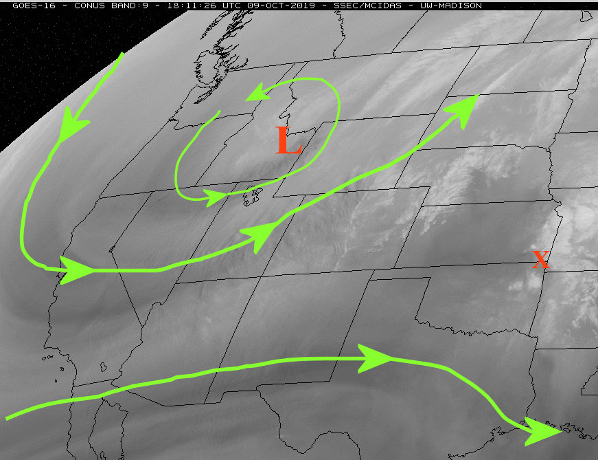
This system was extremely strong and had influenced the jetstream leading to downstream amplification which ultimately was dislodging the cold air. Farther downstream, the amplification was unseasonably strong across the northern Rockies with the center indicated by the red L on the following satellite....

BTW, this location of the upper trough and the amplitude of the cold air that built up just "may" be one part of the pattern we see this winter and next spring! More on that in later posts.
The red X across southeast Kansas was a weak system on the southern periphery of the western U.S. dip in the winds aloft. It brought scattered thunderstorms to much of the southeastern 1/2 of Kansas this Wednesday morning.
So back to this cold air. At Noon today (Wednesday) there was quite a contrast across the central U.S....

The front separating this contrast was racing south and will overspread much of the high plains throughout Thursday. The location of the associated surface low and upper system will favor the Rockies and into the northern Plains as far as precipitation goes. The amount of snowfall, especially across parts of the western Corn Belt may be record breaking for this time of year. For the high plains, we will be mostly on the dry side although there could be just a little bit of rain or even snow (insignificant). The cold, however, will be record breaking for this early in the year. Here are possible low temperatures expected by Friday morning....
Keep in mind, these temperatures will also be associated with a lot of wind so the freezing aspect will be much more extreme than normally experienced for fall systems.
The cold will linger into Saturday but then moderating temperatures can be expected into next week.
Remember, early fall is a tricky time to make a long range outlook. Having said that, some of the signals across the western Pacific point to a possible increase in opportunities for more precipitation starting late next week. No computer models are indicating much of anything for the high plains through the 25th of this month. But, I will be highly surprised if we don't go into a period of increased thunderstorm activity and mild/warm temperatures by the 18th. The main issue I see is getting Gulf moisture back this far if there are frequent fronts. Having said that, the best opportunities will be east of the 100th meridian (not high plains but central and eastern plains).

That helped some on the expanding drought (eastern edge) for some but unfortunately not all. Unfortunately for some there was excessive rainfall!
Here is the latest drought map.

Attention turns to this nasty change in the weather coming up. In the previous post, I was NOT anticipating a killing freeze other than the northern plains and upper midwest. There simply were NO signals as of September 28 that there would be a pattern shift to allow for what is about to happen.
Long time readers of this blog have heard this before. The transition from Summer to Fall across the northern Hemisphere is a very tricky time to make long range weather predictions. The westerlies (winds aloft) across the northern hemisphere start to increase in amplitude and at some point in early October start a wave harmonic with emphasis on locations of troughs and ridges changing from year-to-year. These ridges and troughs are likely set based on atmospheric forcing that also changes every year. I can only speculate on which area (oceans, landmass, tropics, etc.) will provide the greatest forcing this time around. Once this wave harmonic has formed, it then propagates across the globe at various speeds. This continues for about 10 1/2 to 11 1/2 months.
So, back to the September 28 posting where there were NO indications of this unseasonably cold that is happening or about to happen. On the 28th, the "new" wave harmonic had not formed. But now, we're in the very early stages of this new harmonic (pattern). There was already anonymously cold air across Canada, just waiting for an excuse to be dislodged south. That excuse appears to be a super typhoon out in the western Pacific. Here is the latest satellite image showing that system (the bright white with a dark hole - the eye)....

This system was extremely strong and had influenced the jetstream leading to downstream amplification which ultimately was dislodging the cold air. Farther downstream, the amplification was unseasonably strong across the northern Rockies with the center indicated by the red L on the following satellite....

BTW, this location of the upper trough and the amplitude of the cold air that built up just "may" be one part of the pattern we see this winter and next spring! More on that in later posts.
The red X across southeast Kansas was a weak system on the southern periphery of the western U.S. dip in the winds aloft. It brought scattered thunderstorms to much of the southeastern 1/2 of Kansas this Wednesday morning.
So back to this cold air. At Noon today (Wednesday) there was quite a contrast across the central U.S....

The front separating this contrast was racing south and will overspread much of the high plains throughout Thursday. The location of the associated surface low and upper system will favor the Rockies and into the northern Plains as far as precipitation goes. The amount of snowfall, especially across parts of the western Corn Belt may be record breaking for this time of year. For the high plains, we will be mostly on the dry side although there could be just a little bit of rain or even snow (insignificant). The cold, however, will be record breaking for this early in the year. Here are possible low temperatures expected by Friday morning....
Keep in mind, these temperatures will also be associated with a lot of wind so the freezing aspect will be much more extreme than normally experienced for fall systems.
The cold will linger into Saturday but then moderating temperatures can be expected into next week.
Remember, early fall is a tricky time to make a long range outlook. Having said that, some of the signals across the western Pacific point to a possible increase in opportunities for more precipitation starting late next week. No computer models are indicating much of anything for the high plains through the 25th of this month. But, I will be highly surprised if we don't go into a period of increased thunderstorm activity and mild/warm temperatures by the 18th. The main issue I see is getting Gulf moisture back this far if there are frequent fronts. Having said that, the best opportunities will be east of the 100th meridian (not high plains but central and eastern plains).
Saturday, September 28, 2019
Update - September 28, 2019
Apologies to those faithful followers of this blog. As many of you know, these posts are done outside of my normal National Weather Service function, i.e., on my own time. This past month or so has been particularly challenging for me - and my family.
During this past 30 days, there continued to be ample to excessive rainfall across many areas that had received copious moisture for 2019. But, unfortunately, there continued to be a region that missed out - again. Here is a map of rainfall this past 30 days....
The drought monitor has really not changed a whole lot across the western high plains. Maybe shifted a little west? But the moderate drought persists across southwest Kansas.
I've done weather and climate presentations lately and I pointed out that signals and the general weather pattern suggested an increase in the opportunity for beneficial rains for the last days of September and going into early October.
Looking at this mornings satellite image....
There was an anomalously cold airmass (for late September) that had slipped south out of western Canada. A very strong upper level low across the northwest U.S., has set the stage for perhaps record breaking snowfall (for September) across western Montana and adjacent higher terrain. The fringe of this cold airmass has nudged into the plains this Saturday morning. The boundary separating the very humid and warm airmass across Oklahoma and the colder air will produce a round of thunderstorms as an upper level disturbance (that red X on the satellite) moves into the central U.S.. Unfortunately, much of the drought area will miss out on that round. However, it's not done!
The upper level low will continue to strengthen and drop south. This evolution will tap into a tropical system south of Baja California. As this all progresses, waves of "energy" and moisture will stream north and east. It will be a tropical airmass overriding the surface boundary that will waffle north and south across the area. The following map is the most likely area and amounts of precipitation expected through the end of next week, although the majority will fall by late Tuesday....
Don't take the amounts literally or the exact location. In fact the location of heavier rains is still uncertain as the eventual track of the surface boundary, upper level features and interactions with individual storms is unknown. Regardless of the area of heaviest rains, there is a very high chance that excessive rainfall will occur at some locations.
BTW, I mentioned that this increased opportunity for beneficial rain was expected. This notion was tied to the Madden Julian Oscillation and the conditions across the Pacific. This would also give rise to a drier period by mid-month - and warm again! At this point I don't see an early end to the growing season across the central plains. The Northern plains and the upper midwest will most likely see a freeze from this pattern (by the end of next week). I'm not seeing any indication of a freeze for the central and southern high plains earlier than a climatological normal.
This next week I'll dig into this weather pattern in more detail and go into discussion about the outlook going forward. I most likely won't get a post done until around October 7 - at least that will be my goal. It's possible an update will be done Wednesday (2nd).
During this past 30 days, there continued to be ample to excessive rainfall across many areas that had received copious moisture for 2019. But, unfortunately, there continued to be a region that missed out - again. Here is a map of rainfall this past 30 days....
The drought monitor has really not changed a whole lot across the western high plains. Maybe shifted a little west? But the moderate drought persists across southwest Kansas.
I've done weather and climate presentations lately and I pointed out that signals and the general weather pattern suggested an increase in the opportunity for beneficial rains for the last days of September and going into early October.
Looking at this mornings satellite image....
There was an anomalously cold airmass (for late September) that had slipped south out of western Canada. A very strong upper level low across the northwest U.S., has set the stage for perhaps record breaking snowfall (for September) across western Montana and adjacent higher terrain. The fringe of this cold airmass has nudged into the plains this Saturday morning. The boundary separating the very humid and warm airmass across Oklahoma and the colder air will produce a round of thunderstorms as an upper level disturbance (that red X on the satellite) moves into the central U.S.. Unfortunately, much of the drought area will miss out on that round. However, it's not done!
The upper level low will continue to strengthen and drop south. This evolution will tap into a tropical system south of Baja California. As this all progresses, waves of "energy" and moisture will stream north and east. It will be a tropical airmass overriding the surface boundary that will waffle north and south across the area. The following map is the most likely area and amounts of precipitation expected through the end of next week, although the majority will fall by late Tuesday....
Don't take the amounts literally or the exact location. In fact the location of heavier rains is still uncertain as the eventual track of the surface boundary, upper level features and interactions with individual storms is unknown. Regardless of the area of heaviest rains, there is a very high chance that excessive rainfall will occur at some locations.
BTW, I mentioned that this increased opportunity for beneficial rain was expected. This notion was tied to the Madden Julian Oscillation and the conditions across the Pacific. This would also give rise to a drier period by mid-month - and warm again! At this point I don't see an early end to the growing season across the central plains. The Northern plains and the upper midwest will most likely see a freeze from this pattern (by the end of next week). I'm not seeing any indication of a freeze for the central and southern high plains earlier than a climatological normal.
This next week I'll dig into this weather pattern in more detail and go into discussion about the outlook going forward. I most likely won't get a post done until around October 7 - at least that will be my goal. It's possible an update will be done Wednesday (2nd).
Subscribe to:
Posts (Atom)