I'm missing my deadlines! I finally found a little time for an update.
In the previous post I did on the 9th (read it by clicking here) I discussed a weather system that would likely pass south of the central U.S. and benefit mostly Oklahoma and Texas. That did just about as expected. There were a few areas in the high plains of Kansas that got some rain, but not a whole lot (the most I saw was 0.28"). Some areas got nothing more than sprinkles.
The atmosphere is still buzzing for some areas of the country. California is getting battered again by a very wet storm and with several more lined up. It's been my experience that when central and southern California get slammed with a storm, the plains usually benefit too. But not this winter! These storms have been reaching the west coast as mature systems and then they weaken as they move east before re-intensifying somewhere around the lower Mississippi Valley. This time, it's just the way the atmosphere is set up. Granted we had the huge storm in mid-January (and maybe that opportunity will return March), but for the most part the storms have been disorganized and in the wrong position for at least western Kansas to benefit.
Current situation (as of Saturday the 18th)...
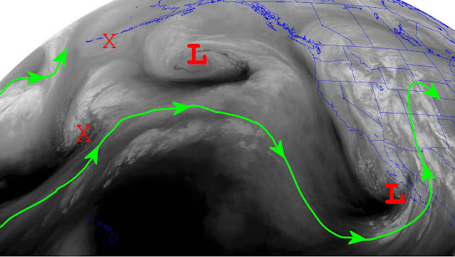
Looking at the satellite image....
There was an upper low moving into Arkansas. But, this was mostly a DRY system as moisture had been scoured out by the previous system that was already out to sea. It became a non-factor for any weather for the high plains. The next system was very wet and bringing a ton of moisture to the western U.S. The center of the storm was just barely visible on the satellite image above. But looking from the Pacific view...
The center of the this very wet storm pounding the western U.S. was moving east and southeast and centered near central Baja California. But it was also starting to go through a weakening process. It will bring showers and thunderstorms to the EASTERN parts of the central and southern plains Sunday night and Monday.
Another system out in the Pacific north of Hawaii will bring more rains and snow to the western U.S. and will impact the central part of the country sometime around Thursday or Friday (23rd/24th). But instead of going through a weakening phase, it looks like a temporary break in the pattern will allow it to main intensity or even strengthen. The result will be a powerful storm in the central U.S. BUT, there is much uncertainty on the eventual location. It could be as far south as Kansas, but more than likely it will impact Nebraska/South Dakota and on east. Blizzard conditions will likely occur in the cold sector (again most likely north of Kansas). One aspect that will be common regardless of the eventual location will be a lot of wind.
Behind that late week storm, cold air will finally return to the high plains and could be present more times than not into early March. As far as precipitation, there is at least a few opportunities showing up as we get towards the end of the month and into March.
If you have had the time to read a lot of posts I've done in the past, you would have read about how the atmosphere sets up in the fall and then cycles at various lengths throughout the fall, winter, spring and summer before eventually falling apart. The weather will never be exactly the same, but trends can be forecast and therefore "most likely" scenarios can be presented. The cycles will repeat with a periodicity of 30 to 70 days. This years pattern of atmospheric flow looks like it's repeating between 58 and 62 days (maybe closer to 59).
The pattern is currently in the 3rd cycle of repeating. I BUSTED big time on this 3rd cycle so far! The beginning cycle brought record warmth during the fall. The second cycle brought the brutally cold air in December. This third cycle, so far, has brought a return of the general flow much like what occurred in October! It may be the extremely robust MJO that threw this off. I don't know. The biggest part of the upper flow has been a persistent in the jetstream pattern that keeps developing across the central part of the country. That allowed for record warmth during the fall and that has repeated during the first part of this 3rd cycle for February.
Now the question is will cycles 1, 3, 5 be the same while 2, 4 and 6 resemble each other? Well, I'll talk more about that in the next post or two. Regardless, there should be a cooling trend starting right after next weeks storm, and in general the pattern should be much cooler (colder) for 10 to 14 days. I do know that there has been a westerly wind burst in the western Pacific that has caused the Southern Oscillation Index to absolutely crash. This type of activity normally causes wild pattern changes across the U.S. about 2 weeks later.
BTW, here is a graph of temperature anomalies showing some of this cycling for Dodge City. Again, it's not going to be exactly the same, but there are some stark similarities. The biggest similarities occur in the upper part of the atmosphere. The second cycle was colder (relative to normal departures) than the first. The third cycle so far is very close to the first.
I'll shoot for another update late next week.


No comments:
Post a Comment