Wednesday, February 1, 2023

Weather Systems are on schedule?

 First - if you haven't been visiting this blog site lately, please review the one I did on January 20 (click here) to read up on how this blog will be handled going forward.  With my consulting company, Hutton Weather Futures LLC, I will provide more detail in outlooks emailed to subscribers and the reports will of course be much more frequent as a subscription service.  That web address is https://huttonweatherfutures.com/.  I will only occasionally update this blog site "swkswx.blogspot.com". 

As I have mentioned in the reports I have been emailing to my customers, weather systems in this current pattern are on schedule.  The next system that I have targeted for February 7-8 has been showing up in some of the long-range computer forecast models but with inconsistent timing and inconsistent features.  Confidence is fairly high that there will be impacts across parts of the Great Plains.  Details at this point are uncertain.

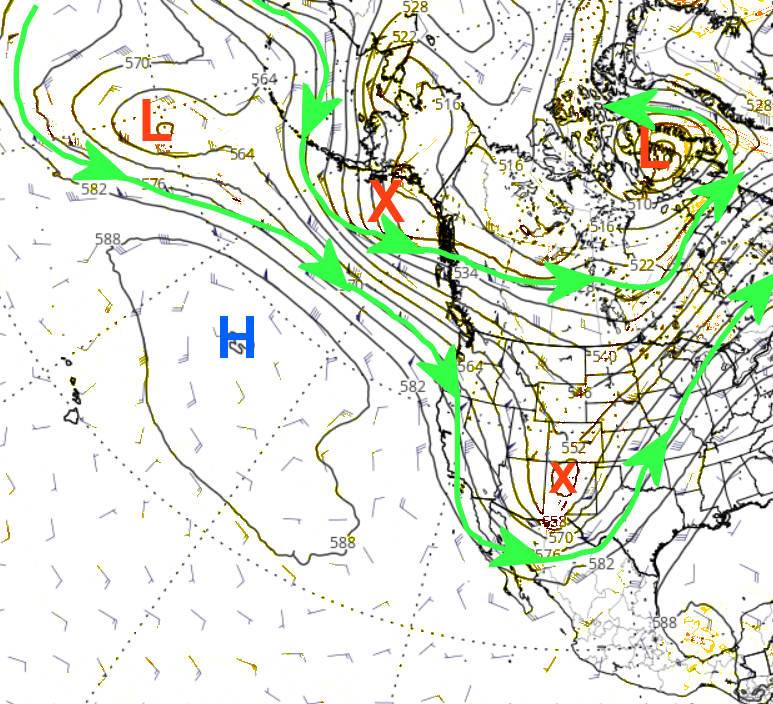
Looking at the current upper air map, any potential storm for next week is not really showing up on this map at least as of Wednesday evening (1st)....


The storm moving across northern Mexico has been weakening but still very capable of producing a widespread precipitation event from southwest Texas and eventually into the lower Mississippi Valley.  It is way too far south to impact the central plains.   The strong system across the eastern Pacific (the big red L) will be moving northeast into Canada and will only promote warming for the central plains but with no indication of any moisture.

Any potential storm next week hopefully will benefit the area that has been consistently getting missed as you can see in the precipitation maps for January (the first is the amount and 2nd is the precent of normal).


For January that is a hefty amount of precipitation for Nebraska and northwest Kansas!

Again, I have started the subscription service at https://huttonweatherfutures.com.  I hope you will consider subscribing and join the others receiving these frequent updates of the expected weather as we get into the growing season.

Friday, January 20, 2023

Subscription Services have begun - 2nd and 3rd storms

If you read the previous blog posting on the 27th (read it by clicking here) then you are aware that I retired from my position with the National Weather Service at the end of 2022.  I have since formed my weather consulting company - Hutton Weather Futures, LLC and will be providing a more specific form of weather outlooks that are similar to what you may have read in this blog.  It is a subscription-based opportunity for you to receive valuable insight into what can be expected weather-wise far into extended periods to help in your business needs.  Access to the data is through a weekly (or as needed in between a weekly report) that will be emailed to you.  The pricing structure is stated on my company's website, and that is:

https://huttonweatherfutures.com/

I hope you will consider the opportunity to receive these reports that will be delivered on a consistent basis (with occasional updates).  I will likely "occasionally" post here on this blog site but without as much detail as I hope to provide with the subscription-based service. 

In that previous blog posting on the 27th, I had mentioned three potential systems that could benefit much of the western high plains.  It was unclear on the track of number 2 and 3.  The first system behaved as expected with the biggest impacts being across northeast Colorado and far northwest Kansas and into Nebraska.  Amounts for much of southwest Kansas were very light in most areas, but anything helps settling the dust, I guess.


System number 2 that is expected this Friday evening and into Saturday will be rather compact, but the eventual track will benefit much of the area that was missed by system number 1.  I would not be surprised to see six-inch snow amounts at some locations across western Kansas but especially into southeast Colorado. Unfortunately, there will be a sharp gradient on the south side of the snow area and those south of the gradient will not get much, if at all.  The location of the snow shield will not be known until the event starts.  Moisture content in the snow will be on the wetter side!

System number 3 will impact the region late Sunday into Monday.  The eventual track could be making it an Oklahoma storm, but that track is highly suspect.

Again, please visit my website for details on a subscription-based service...

https://huttonweatherfutures.com/


Tuesday, January 17, 2023

Three storms and who will benefit - plus I'm transitioning to Hutton Weather Futures LLC

As many of you are aware, I retired from my position with the National Weather Service at the end of 2022.  However, I'm not leaving weather as a profession.  I have since formed my consulting company - Hutton Weather Futures, LLC.  I will be providing a more specific form of weather outlooks that are similar to what you may have read in this blog.  It's in the formative stages at this point but will be gaining ground quickly.  It will be a subscription based opportunity for you to receive valuable insight into what can be expected weather-wise far into extended periods to help in your business needs.  At this point, access to the data will likely be a through a weekly or sub-weekly report (or as needed in between a weekly report).  The pricing structure is still be worked on. I hope to have everything ironed out by the end of this week (20th) and details will be shared in this blog.  Stay tuned by checking back. 

In the past week I've spoken at several meetings discussing this awful weather situation that much of the high plains has been in.  The one silver lining is that there have been weather systems, but unfortunately they have not benefited much of the high plains.  Starting tonight and through middle part of next week, there will likely be 3 more opportunities.   Looking at the upper air map from this morning...


A very strong upper level storm was moving towards the Four Corners region.  It has been strong enough to dump copious amounts of snow even as far south as Flagstaff Arizona.  The issue (as is typical) will be the eventual track of the storm as it moves out into the plains.  Unfortunately for much of the high plains of Kansas down into west Texas, the system will track too far north to bring significant moisture.  Northeast Colorado, Northwest Kansas across much of Nebraska there will be a large area of heavy snow.  Across the eastern half of Kansas there will be pretty fair amount of rain and even freezing rain closer to the Nebraska/Kansas border.

A second potential storm, that as of this morning was across the Gulf of Alaska, could impact the plains.  It was set to amplify into the high plains over the coming weekend.  Initial thoughts would have it tracking a farther south so that areas that miss out tonight/Wednesday should get at least some precipitation (likely in the form of snow).  Details are not possible at this point as the system will have to undergo strengthening and amplifying before any idea will come into light.  But, fingers crossed!

A third system is simply a small disturbance aloft that was currently way out in the Pacific.  It is denoted by the red X on the top left corner of the map above.  There is some possibility that it could be a system to watch by the middle part of next week.  There is a tremendous amount of uncertainty.

Here is the early look at what could fall through next Tuesday (image from the Weather Prediction Center)


An important point though is that all three of the systems may miss much of the high plains of Kansas into the southern high plains.  As stated above, there have been systems all fall and winter but most have bypassed the hardest hit region of the drought.

Speaking of which, here is the latest drought map.


California has certainly improved in that category!  Here is a percent of normal precipitation since the beginning of January.  


Some of the snowpack stations are already above the seasonal normal and some are approaching record amounts of moisture in the snow -  already!  If only we could get just a taste of that.

So to recap...

I've started a company - Hutton Weather Futures, LLC.  Frequent (at a minimum weekly, but with updates) reports will be emailed to subscribers.  The pricing structure has not been set but hopefully I will be ready to go by the end of the week.  Details are forthcoming and will be posted in this blog.  BTW, this blog will probably continue but on an in-frequent basis with less detail.


Tuesday, December 20, 2022

Brief update

This will have to be very brief.  My NWS is coming to a close and I have been swamped in that preparation.

The expected cold mentioned in the previous post has come to fruition and will culminate with brutally cold and wind Thursday and into the early weekend.  Any meaningful snow will concentrate on the midwest but won't help in any drought concerns as it will be very dry.  The biggest issue will be the cold (actual temperatures and wind chill indices), as shown below.

The upper air pattern is ideal with the cold buildup across the higher latitudes of North America and is being unleashed south as the blocking high had developed across Greenland.  Here is the upper air map as of this morning...


Expected temperatures Friday morning (and keep in mind Thursday temperatures will not be much warmer and wind chill indices will be extremely cold)...


Warmer weather is expected the last few days of December.  January - I need to find some time to look it over.

BTW, here is a map of precipitation that occurred yesterday by a little weak weather system.


I'm not sure I will be able to update until after the first of the year - as a Non-National Weather Service but as a consulting Meteorologist.  Changes are coming!


Friday, December 9, 2022

The pattern may be set

In the previous post on 11/23/22 (read it by clicking here) the headline was "another swing and a miss?".  I also discussed that this year's pattern was not quite set, or so it would appear.  With the system this week (southeast of the area across mainly Oklahoma but a secondary moving well north) and the system moving by this Friday night and Saturday (again mainly southeast of the area), I believe I have a pretty good idea of the nature of the pattern.  Is it concerning that much of the high plains has been left high and dry?  Absolutely.  But with the changing of the seasons (fall into winter, winter into spring, and spring into summer), the pattern will shift around enough that it won't be totally gloom and doom.  Now to time it.

The system(s) the past 2 days brought good moisture to Oklahoma again (and into the Corn Belt).  Here is a map of that precipitation. 


During the past 2 weeks there was "some" precipitation farther into the plains, but not a lot.


The biggest weather news this next week will be a monster storm that is going to impact much of the central part of the country with a blizzard across Nebraska and the Dakotas and severe convective weather farther south and east.  There will be a big concern for a possible outbreak of tornadoes across the Mississippi Valley.  For the high plains (at least the central and southern high plains), it looks like more of the same with dry and way too much wind.  But....

In the past few meetings and presentations that I have been doing, I mentioned the second half of December could be active and very cold.  I've expected this for several weeks because of some connections to the tropics with the higher latitudes; possible blocking of the jetstream;, and a buildup of snowcover across the northern hemisphere. One thing I look at in a shorter time frame (less than 30 days) is the indices of the Arctic Oscillation and the North Atlantic Oscillation. 


It's not unusual for these indices to go strongly negative.  When the Arctic Oscillation goes strongly negative, it is often followed by a deep intrusion of Arctic air into lower latitudes.  Sometimes it's across Europe or Eurasia and sometimes into North America.  It just depends.  When the North Atlantic Oscillation goes deeply negative, there is usually blocking of the jetstream across the Atlantic and into Greenland.  When this happens weather systems tend to slow down and move more meridional. But, when both the AO and NAO go negative, there is quite often a major intrusion of Arctic air into North America, including the U.S..  That is one clue that December is about to get frigid.  Then top it off with the snow that has built up across the northern hemisphere...


BTW, that area of snow cover across the northern hemisphere had been above record levels and still is above the 56 year mean.  Interesting. 

With all this going on and with the pattern that is setting up, the jet stream flow is going to become (or has become) very energetic and volatile.   After this major storm moves by early next week, the remainder of December will, on average, be colder than normal with periodic episodes of snow (including snowfall for the high plains).  The way I see it, many locations across the central and northern U.S., will have a white Christmas or at least the odds favor such.

As far as precipitation, here is what the Weather Prediction Center is expecting through the end of next week.


That is definately a concerning image for the central and southern high plains, especially knowing that there is going to be more wind.  The periodic snow I'm expecting towards the end of the month will help a little.  I would expect those opportunities to repeat a couple of times going into spring.  

My gut feeling going farther into 2023?  It will be a “normal” winter, active spring and probably a dry and hot summer – all subject to updates as the pattern becomes evident.  

With me wrapping up my career in Meteorology with the NWS, I'm not having much time to update this blog but I will attempt to do so again next week.  As mentioned, a month ago or so, changes will be coming to this blog.  More later.


Wednesday, November 23, 2022

Another swing and a miss?

Before I get into the woods....here is the system precipitation that impacted some of the area with rain and snow on the 14th.  At least it was something.


Another strong storm will impact the southern High Plains this holiday but largely miss the central and northern parts of the HP.  This sign is both discouraging but encouraging.  Why encouraging?  Because the atmosphere is capable of intensifying storms "nearby". 

Looking at this morning's upper air map


An intensifying and strong upper system over Wyoming was dropping south.  Unfortunately for much of the high plains of Kansas/Nebraska it will "dig" way too much to benefit much of our area.  It will, however, likely bring very heavy precipitation to west Texas (and some of the panhandle) into Oklahoma.  Some of this will be very heavy snowfall too.  This will be the 3rd or 4th time this fall that a system has behaved in this manner.  That "could" benefit the rest of us later this winter and into the spring.  More on this in later posts. 

The exact track and behavior of this system is still unknown, even though it's 24 hours away!  These types of developing and intensifying systems are just plain unpredictable in terms of location and specifics

Computer models will be ALL OVER THE PLACE!  This leads me into a topic that I have discussed numerous times.  Social Media is a platform that misinformation will be shared routinely.  Computer models struggle mightily.  Here is an example of a computer model solution generated on 11/15 and valid for this week (ending Saturday).


Look at those ridiculous snowfall amounts!  And the placement (WAY OFF).  Just 6 hours later when the same forecast model generated data for the same period, this is what it was showing.  


This type of behavior is not unusual.  The models forecasting many days out just can't be trusted.

In later posts I'll do late next week or the following week, I will dive into the outlook going into spring.  I'm starting to see signs that the first cycle of this year's pattern is about to be set.  I should know more in a couple of weeks or three.


Friday, November 4, 2022

Is there any hope?

The title - of course there is.  All dry periods (droughts too) are broken.  But how much can we endure before favorable weather returns?  In previous posts going back a long way, I had pointed out numerous times that, for instance, Dodge City experienced 7 years in a row (2014-2020) of above normal precipitation.  It was almost 9 in a row as 2013 and 2021 were just a little bit below the annual average.  From 1875 through the current time, there had never been more than 3 years in a row.  So, this was highly anomalous to have that many "wet" years in a row.  The pendulum was going to swing the other way, there was no doubt about it.

Remember, the high plains region is considered to be semi-arid and the farther west towards the front range (from New Mexico into Canada), the more likely it is that the year or season will be dry.  That is just a fact of life.  Even with dry years (or seasons), crops have been raised without irrigation.  Obviously, production will be limited in many cases (depending on the environmental conditions during the growing season). This year and season have been brutal for many.  Will it continue into 2023?  I wish it was easy to say one or other but there are just so many factors/issues that influence sensible weather, especially across the high plains.

In the previous post I did on October 28 (read it by clicking here), I discussed again about the new weather pattern that was setting up.  The new pattern then and as it is today (the 4th of Nov) was and is still young.  I have been mostly discouraged but yet there had been and continue to be at least a few signs of promise.  The last one is the system that is moving out of the Texas Panhandle today.  Overnight there was a fairly large area of rainfall and here is a map of what had fallen as of 9 AM this Friday morning...


Granted, many of the areas hardest hit by the drought and dryness had largely missed out, AGAIN! But the system was still likely to produce at least some rainfall (and snow) farther west.  This type of strong system will make more appearances later this fall and winter.  Even though not all areas got or will get precipitation, the evolution of the system is slightly encouraging.

Speaking of precipitation, the October amount was awful.  Dodge City (airport) got just a trace, and this has happened only 2 other times in recorded weather history (back to October 1874).   


As of this morning, here was the upper level map of the jetstream.


The red X approaching the Texas Panhandle was small but mighty.  The red X moving across the Gulf of Alaska will amplify into a deep trough across the western U.S. which will promote warmer and windy conditions across much of the high plains later this weekend and into the first of next week.  The eventual evolution of any system moving out into the plains will likely be towards the end of the week but there is much uncertainty.

Not shown by a map or chart, but there is a decent Madden Julian Oscillation across the Western Pacific.  Forecasts are pretty consistent on its expected movement and evolution.  It would "favor" much colder and perhaps wetter weather centered on mid-November.  Maybe between the 12th and 18th.  Without knowing much about this new weather pattern, confidence is only slightly there for that mid-November weather outlook. 

For an outlook taking us into next spring.. well without knowing details of the behavior of this new pattern that is just developing, I don't really have an answer.  Can I look at history?  I could, can and will but don't put much stock in it.  

As I mentioned in the previous posting, the current La Nina will likely continue through the winter which would be the third winter in a row of a La Nina.  This has only happened two other times (1973-1976 and 1998-2001).   That is only two events to go off of so that isn't much at all.  But lumping the two events together, for the high plains the November-April weather averages out to near normal precipitation and below normal temperatures.  Again, don't put stock in it.  Once this new pattern has completed its first go round, confidence should increase on an outlook into the growing season of 2023.  For now, definately temper expectations.  I'll try and update later next week.