In the previous post I did on the 18th (click here), I discussed the drying pattern for the winter wheat harvesting areas. So far, that has panned out perfectly. I also mentioned that the window of opportunity might be closing though by the end of the month. That still appears to be on track.
Looking at the satellite image (click for a larger version),
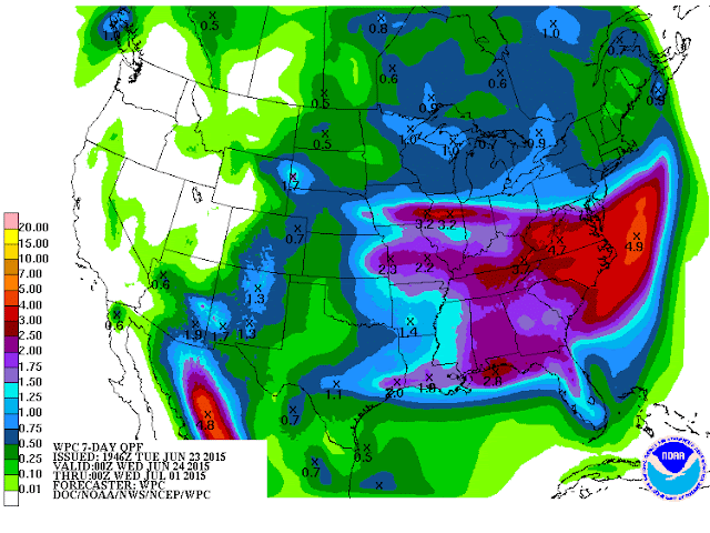
there were hints of the North American Monsoon starting to form (very early stages) as moisture aloft begins to move north through the Rockies. What is preventing widespread precipitation across the plains is very warm air aloft and sinking air (from a large upper level ridge). But this will be breaking down a bit and shifting west. So, the very warm to hot weather with limited thunderstorms and gusty surface winds is about to be temporarily shut down. A cold front will move into the central high plains by Thursday and will bring a round or two of thunderstorms and cooler temperatures (and higher humidity). The WPC has the following solution into next week (for precipitation).
The heaviest rainfall by far will be across much of the corn belt. Hopefully, there won't be enough rain to completely shut down the wheat harvest, but no doubt a few spots will see a couple day delay. Towards the end of the week and into early next week there will be limited chances for thunderstorms across the high plains. Rainfall will, however, be ramping up a bit across the Rockies and adjacent front range.
The kicker will be late next week and into the 4th of July weekend and week. Significant changes may be taking place, especially towards the 3rd-5th of July. If the changes take place, that I'm expecting, the opportunity for rainfall will increase significantly and temperatures will drop to below normal. I guess the headline there would be "Expect Weather Delays Going Into July". I'll have to have a bit more time to discuss this, and I hope to by the end of this week.


No comments:
Post a Comment