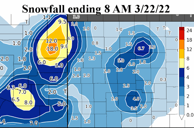
The strong weather system earlier in the week, centered on the 21st, did bring widespread precipitation as expected. But amounts for some of the region were highly impacted by an early development of rain and thunderstorms across Oklahoma and Texas. Thus, the storm total under-preformed for much of the high plains - which is obviously very discouraging.
The large area of rain and thunderstorms mentioned above disrupted the flow of moisture into at least western Kansas. Amounts therefore were not that heavy. But as the storm system finally completed it's development and started lifting out into the central U.S., precipitation picked up again in intensity. Towards the end the intense lifting of the atmosphere it cooled the column enough that snow fell. It's honestly such a crap shoot to determine location, intensity and duration of precipitation and if it will flip to snow. There are just so many variables that can impact actual amounts. One variable is what I mentioned - the large area of thunderstorms that developed across Oklahoma and Texas disrupting the moisture inflow into the storm. I've recently shared similar charts as the forecast from computer models seen below...
Precipitation forecast for Dodge City...
Here is the precipitation map from Monday into Tuesday....
Here is a look of the snowfall for that Monday night (and earlier in eastern Colorado that was hammered).
Overall, here is a look at the amount of precipitation that fell with the storm (just in Kansas)...
Looking ahead, my analysis does indicate another system for early next week. But, there is a strong possibility it will move too far north and east of the high plains (and too fast) to bring much precipitation. Eastern Kansas is another story. There is hope, I'm just not too optimistic at this point. I'm counting on the remnants of the Madden Julian Oscillation mentioned in the previous blog post (click here to read that one). Looking at the jetstream map from this morning, the potential system is indicated by the red X across the Pacific with one potential track overlaid on the map.
That system will have to intensify and track in a perfect location to bring much precipitation to the high plains. Keeping fingers crossed.
Beyond that early week system, my analysis would indicate another possible weather system towards the end of the week. It does exist just off the jetstream map above. Surely one of the two will bring some moisture to the high plains. At least the Weather Prediction Center thinks so. Here is their map of precipitation for next week.
Going into April, the first 14 days of the month looks to be cooler that normal, on average. There will be some warmer days though but offset by several more strong cold fronts. There should be yet another weather system that could bring some moisture - somewhere between the 7th and 10th. Beyond that second week, some of the computer models are indicating much above normal temperatures for the balance of April, and dry! My early analysis would lead me to believe the average temperature for the entire month would be a little above normal but with the possibility of a late freeze. More on that later. Oh - and for those that have been reading this blog for a while. Do you remember that magical date of April 20th that I mentioned several months ago? Let's see what happens.


No comments:
Post a Comment