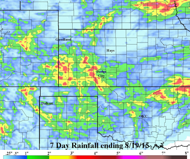
Yet another active period just passed this past week across a large part of the high plains. I traveled to Lubbock this past weekend and was amazed at the water standing, the lushness of the pastures and the stark contrast from just a few years ago.
The weather pattern that set up last fall has continued into this late summer, but of course with seasonal variations. How long will this continue? Typically the pattern starts to decay as we go into late August and September. It is amazing what happened about 43 days ago. At that time there were two powerful typhoons in the western Pacific. Today, almost exactly the same occurrence!
With the active Pacific, cold fronts have been a little more common this summer. The front that moved through much of the plains on Tuesday (18th) has brought a rather chilly airmass. Low temperatures this morning were much below normal and highs will struggle to warm much on this Wednesday. Yet another front is expected over the weekend.
Over the past week, copious amounts of rain fell at a lot of locations! (click for a larger version).
As has been typical of this year, rainfall has varied tremendously from location to another, over a very short distance! For the year so far it really hasn't averaged out. Yearly rainfall from one location to the next has also been quite variable. The following map is for precipitation for the year ending on the 18th of August.
By the way, some observing locations are approaching a record amount of yearly precipitation, all ready!
Looking ahead...
This mornings satellite showed an anomalously strong upper level system and also anomalously far south. This is one reason why the strong cold front (summer standards) has moved so far south. One thing you might note is the lack of the North American Monsoon moisture which typically extends well into the Rockies. It has temporarily shifted way south into Mexico.
The flow across the midwest will dominate for another day or so. Then high pressure aloft will begin to amplify but as it does it will force another front into the central plains later in the weekend. This should bring another round of rainfall, but this time perhaps farther east. Thus, the heavier rain with that may be across the EASTERN Lower Plains.
Beyond this weekend the upper pattern is uncertain, primarily because of the tropical activity across the Pacific. I have a hunch that later next week will warm up significantly again but there may also be more chances for thunderstorms. But, there is also a possibility that the pattern weakens enough so that the weather gets quiet, but warm. More later...


No comments:
Post a Comment