Friday, February 1, 2019

Update - February 1, 2019

This past few weeks has been pretty active, especially for areas north and east of the high plains of the Kansas area.   The brutal cold that centered on the midwest/Great Lakes was a doozy and record breaking for "some" areas.  I puke every time I see posts (media and social media) that the Polar Vortex was fully responsible and act like it's never happened before. I've discussed this before in this blog.  The "polar vortex" is present all the time and it's southward intrusion into the U.S. happens on occasion.  It's most prominent during the winter.  THIS IS NOTHING NEW!  Good lord!

In the previous post I did on the 13th, I was expecting this cold.  But I also was expecting it to be a little farther west bringing a pretty good possibility of below zero readings to the high plains.  Instead, the sub-zero readings were as far west as eastern Kansas.  I did mention below normal temperatures for the high plains for the period January 21-31 and indeed that did happen.  For example, here is what Dodge City observed....                                                                    


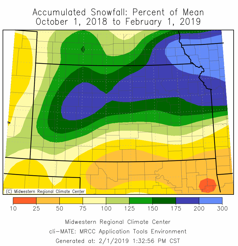
I've heard from quite a few folks about the mess in the feedlots across much of western Kansas.  With so much moisture since the fall and without a lengthy drying period, the pens are full of muck that can't be cleaned up much without really cold weather.  Here is a look at the percent of normal of what has fallen since October 1, 2018...


Without checking, I bet for this time of year this has to be in a top 10 for record keeping.  If I get some time, I might check into.  Regardless, it's been really wet with many areas over 3x the climate  normal.

Back in the early Fall, the outlook I gave was for the winter to be near to below normal on temperatures and above normal precipitation, including so.  So far (Dec-Jan) it's been a little warmer on average. 


Snowfall/precipitation has been above to much above average and many locations (while conversely snowfall has lacked in other areas where it was rain and not snow during the weather events).


With the continued wetness, the long term drought map does not show any area of Kansas in a drought.


So what's next?

The pattern is changing again.  The brutal cold that is gripping the midwest is lifting out and moving east as the jetstream will undergo a transition from northwest to southeast to southwest to northeast with time.

Looking at the latest satellite image from this Friday afternoon....


There was a decent storm headed towards the west coast.  This system will weaken once it gets past the Rockies late this weekend.  But before that happens, it will dump feet of snow on the high country of Colorado.  Also, it will cause a surface response across the high plains where much warmer air will result, and unfortunately temporarily increase the wildfire danger. 

Once this system moves by, cold air will drop in behind it for the first of the week.  The second system (red X on the satellite image above) will approach the central U.S. by mid-week (~6th).  Many uncertainties exist for that system since it's many days out.  Much of the high plains should be well into the cold air .  Precipitation would most likely snow or freezing rain.  Specific details are not forecastable with any degree of accuracy at this point but it might be a system that will cause impacts.

Beyond the mid-week system, I continue to expect an active pattern for February and into early March.  A day or two either side of February 13 is one target date but with low confidence.  In addition, more outbreaks of very cold air can be expected this month and this time centered farther west.  I'm pretty confident that precipitation will be above average for February and temperatures below normal causing more impacts to the cattle industry on the plains.

Later, from mid-March and into April we could very possibly have what I call a "false spring" and then get greeted with a late April/early May punch in the gut. I'll discuss that later this winter.

I'll try and update again sometime next week.


Sunday, January 13, 2019

Update - January 13, 2019

It's been a while!  This past five weeks have been a little stressful with personal obligations, end-of-the year activities at work, and now the partial government shutdown.  My job at the NWS is one where we continue to work providing forecasts and data to continue the mission of the organization.  But we are NOT allowed to do any travel, presentations, or do anything that does not provide life and property saving activities.  The biggest kick in the chin is that while we work, there won't be a paycheck until the standoff in DC ends (have already missed one).

Since this free blog you are reading is done on my own personal time, my motivation has been lacking. I'm passionate about weather and especially long range forecasting.  But the physiological wear of current events is dragging me down.  None-the-less....here is a quick rundown on what's going on...

 I wish I would have had the gumption to do a blog entry back in early January.  Based on my knowledge of the pattern that set up this fall, I was able to inform quite a few folks in person (as early as January 3rd) about the storm that just happened.  I did this even though there were NO computer forecast models predicting any precip for a long stretch of time.  Models didn't pick up on the possibility until about 4 days out.

This past 30 days have been exceedingly wet across much of the central U.S. and here is a map showing hefty amounts, especially for winter!


Really this just continues the wettness that has persisted for some time.

All the rain and snow that has occurred this fall and winter across the mid section has wiped out the longterm drought.  Plus, the drought across the four corners region should be seeing a big dent too!


This evening the satellite image showed several important features.


The first feature is the system coming into the west coast.  It won't be much of a weather maker for the high plains as far as precipitation as it will be weakening quite a bit.  But as it moves across the area Tuesday and Wednesday, it may help to hold low clouds across the region, especially where there is snow cover.  In general, this may be a cloudy and chilly week, especially across the eastern parts of the high plains and points east.

The blue H on the satellite image represents an upper high that is ridging towards the north pole.  A very cold airmass (Arctic) is developing across the high latitudes and is poised to race south into the U.S. later in the week. The first shot will be behind a system that has not yet developed but will be moving across the central U.S. this coming Friday and Saturday (18th-19th).  That system will likely combine with the Arctic air to bring more snow (less moisture this time), but those details of snow are not forecastable at this point.  Temperatures though will plummet with very low wind chills.

After the brief shot of Arctic air late Friday/Saturday, there may be a day or two that temperatures moderate a bit, but not a lot.   A bigger shot of Arctic air is likely that following week!  Which takes us to the robust MJO that is on the bottom left hand corner of the satellite image.  This feature has already produced a response in the atmosphere this past 2-3 weeks.  The additional forcing with that and the combination with flow across high latitudes will likely bring much below normal temperatures for the period January 21-31.  Between this coming weekend and through the end of the month, I will be very surprised if we don't get below zero temperatures (wind chill readings will be much lower).  There may be additional snow too beyond this late week system

Going into February, it could remain relatively active.  I'm guessing above normal snowfall and below normal temperatures.


Friday, December 7, 2018

In the post I did a few days ago on the 4th (you can read that by clicking here), I discussed the upcoming weekend storm moving south of Kansas with the expected precipitation being just south of Kansas.  The storm this morning was near San Diego and that is denoted by the red L on the following satellite image...


In most winters storms in this vicinity moving towards the central U.S., they would benefit the local region with precipitation (whether that be liquid, freezing or frozen).  This particular storm has already brought copious amounts of rain and snow to California and good for them!  But as the storm continues to trek to the east and even southeast, it is also going through a weakening trend.  Regardless it will eventually produce a ton of rainfall across Texas and parts of Oklahoma.  It does appear that it will pass WAY south of the central U.S. and may even be so far south that the northern extent of precipitation may not even reach Oklahoma City!

So far this fall and early winter, the first part was very wet across the central part of the plains, centered on Kansas.  Later weather systems started trending north and impacted Nebraska, the midwest and eastern Kansas as we got deeper into fall.  Now with this weekend storm going so far south, there does seem to be a signal - a signal that I'm a little concerned about as far as future precipitation trends for the high plains, even going well into the growing season (including summer). I'm hoping this is just an adjustment period as the overall weather pattern (upper troughs and ridges) has been set for this next 10-11 months.

I'm not going to change my thoughts on near to below normal temperatures for the winter, nor will I waver from a normal to above normal precipitation outlook - at least just yet.  The change may be just temporary.

For the next couple of weeks it appears that weather systems may weaken as they approach the central U.S., but then intensify again just east of Kansas.   I'm still not seeing a signal for the brutally cold air, even though the Arctic Oscillation and MJO have been in a favorable phase.

Here is the precipitation outlook through the end of next week...


I'll try and update again in about a week.


Tuesday, December 4, 2018

Update - 12/4/18

The active pattern continues across the central U.S. but with locations being impacted the greatest shifting north and then south.  The post Thanksgiving "mini" blizzard on that following Sunday was tame compared to the storm that came through this past weekend (1st/2nd). That weather system produced copious amounts of rainfall across eastern Kansas and very heavy snow across Nebraska.  Based on soil moisture profiles, much of the eastern half of Kansas is fully saturated.  Only light amounts of moisture fell on the high plains.  Farther south and east there were two days of severe weather including tornadoes in Oklahoma and then especially Illinois.

In the previous post I had mentioned that weather systems so far this fall have been farther south and stronger than originally forecast.  Although this past system took a northern route, it was expected to do so.

This morning there was a dusting of snow across Kansas from just weak forcing aloft.  No biggie.

In the last post I did on the 26th, I pointed out a system way out in the Pacific near Guam.  That system is now going to be our next impacting storm.  However, this time it appears that it will take a southern track!  While it will be very wet across California and Arizona, the storm will be weakening as it moves east.  It will, however, be strong enough to pull copious amount of moisture northward as it moves into the southern plains.  Oklahoma and Texas and then eventually the gulf coast will most likely receive a lot of rain! On the northern fringes there will be ice and snow, but the details of areal extent are impossible to lay down at this point, since the system is still off the coast.  At this point the northern edge of the precipitation shield will likely be just south of Kansas.  But hold on!

On this mornings satellite image, the low shows up as the swirl in the moisture off the west coast...


Since the system is still off the coast, the exact track is still highly uncertain. Yes, there is still a chance it could move farther north.  The farther north the track, the farther north the precipitation.  In Kansas the temperature profile would support snow.   I might have a chance to throw out another post at the end of the week, but it's best to just follow the National Weather Service (www.weather.gov/) for details as we get closer to the weekend.

Even though temperatures have been below average for a while, there still isn't any indication of the brutally cold Arctic air that's been building.  With the sharp ridge aloft just off the west coast earlier this fall broken down, at least temporarily, it will be difficult to get the really cold stuff.  But that ridge will likely reform yet this month.

Back to that satellite image....there are two areas of flow aloft from the deep tropics across the Pacific near the equator.  In fact, there may be a tropical storm develop southeast of Hawaii!  On the 25th there was just one area of flow from the tropics.  I'll have to watch this because usually exciting things happen across the central U.S. with this tropical energy being transported into higher latitudes.  Regardless, this should keep an active pattern across the country.  For the high plains, it could be Oklahoma/Texas that are impacted the greatest, or it could shift north into Kansas and Nebraska, but not the Dakotas or upper midwest.  More in later posts.

BTW, here is the precipitation outlook from the Weather Prediction Center through next Tuesday the 11th.


Monday, November 26, 2018

Quick update - 11/26/18

Back on 11/12/18 in the previous post I did, I ended with:

"I would not be surprised to see something around Thanksgiving or shortly after."  

Obviously there was a pretty major blizzard across parts of the central U.S. and midwest yesterday.  That system intensified as it moved out of the Rockies and was a little farther south than what many forecasters (and computer forecast models) had predicted.  There has already been a half dozen systems or so this fall that have been stronger and farther south than what had been expected, and that just MIGHT BE the trend this winter.  

Since the previous post on the 12th, the flow aloft has changed, at least temporarily.   Back on the 12th there was a very amplified ridge aloft across the west coast and that has since broken down enough to allow flow aloft to enter the western U.S., bringing heavy snows to much of the Sierra Nevada range (and also to the central Rockies).  On the satellite image below....


The bright area across the bottom of the image circled by blue represents deep tropical moisture, most likely associated with the warmer than average sea surface temperatures (i.e., the developing El Nino).  There has been an atmospheric response/coupling from these warm waters in the form of a sub-tropical jet stream transporting energy and moisture north into the higher latitudes.   In addition, there is a pretty good upper low near Guam across the central equatorial Pacific.  That could be a player in the U.S. weather a little down the line.  There is also a deep and strong system across the Gulf Of Alaska. 

All told, the flow aloft will continue to be rather active for the next 10 to 14 days.  There should be several more impacting storms across the central U.S., but details of timing, intensity and location will be unknown until they develop and enter the continent.  The first may be as early as the end of this week and the following may occur towards the end of the weekend or first of the next week (Dec 2-5).  Brutal cold air is not showing up at the moment.  But there is a rather robust MJO developing and the impacts may be much colder air as we get into December.   More on that later.

I'll try to update again by the weekend.


Monday, November 12, 2018

Update 11/12/18

The post I did a week ago on the 5th, I discussed a developing system that was to bring some snow to the central part of the country.  There had been many shares of a viral post about 6 to 12 inches of snow expected.  As I have mentioned numerous times in this blog, often someone will post a map of computer generated snow or rain amounts (that usually changes dramatically every six hours).  If it's "exciting", the post will usually go viral as people just blindly post or share these maps without any thought to the validity.  I guess that goes for just about everything.  Shoot even this morning there is a viral post about a huge whitetail deer that was reportedly hit by a vehicle south of Dodge City over the weekend.  It was a picture of a deer that has been circulating the internet for THREE years!

Back to that first system that occurred mid-week.  As I mentioned in that post (you can read it by clicking here), I was expecting a very narrow band of heavier precipitation (snowfall) that could be from a lot to basically nothing!  There ended up being several narrow bands.  The heaviest near St. Francis in far northwest Kansas and around 5-6 inches in the flint hills of eastern Kansas.  Dodge City for instance only got 1/2 inch and areas west and southwest got nothing at all!

The weather system that occurred yesterday (Sunday) and overnight was much stronger and more capable of producing heavier snowfall than what it originally appeared.  At this time last week when I did that post, there was just a "hint" of something that looked like it would impact southeast Colorado and into eastern New Mexico and into parts of the panhandles for late in the weekend.   Since it ended up stronger and more functional, that just might be a sign of things to come for this winter and following spring. 

Looking at this mornings satellite, the system that brought the snow is the red X across eastern New Mexico....


On the satellite image, one very important feature is the blue squiggly line that stretches up into Alaska.  That represents a sharp ridge aloft.  It's in a perfect location to allow systems to amplify as they drop into the Rockies which can also bring major shots of cold air into the U.S..  This ridge won't be in that location ALL the time, but I have a hunch that it will be there at least in the background of the flow aloft, meaning there will be repeats throughout the winter. When this occurs again during the dead of the winter, I have pretty high confidence of below zero temperatures across the high plains several times this cold season.

Something else on the satellite image...there are three areas that winds aloft are moving from the deep tropics to higher latitudes (the green arrows from the bottom of the image to the top).  This will continue to be sources of forcing going into the spring.  More on that later....

For this week, temperatures will be moderated by the snow cover with highs generally below normal until mid-week.  Lows tonight should drop well into the single digits.  There is another hint of a minor system for the weekend.  Will it also be stronger than expected and produce more snow?  I'm not too confident of that, but additional cold air looks like a strong possibility.

Following that system this coming weekend, I'm not seeing much at the moment although I would not be surprised to see something around Thanksgiving or shortly after.  Regardless, much warmer weather does seem to be in the offing beginning next week. 

The overall pattern is still in a flux and not set yet as it continues to develop and get established.  At some point during the next 2 to 3 weeks there should be a southwest U.S. or southern Rockies storm.  I'll attempt to update again in about a week.