Unfortunately, most of us had less than 1 to 4 inches and the snow was accompanied by wind. The snow really wasn't as dry as might be expected but it really did not help with the drought situation (other than that small area noted above).
Instead of posting the drought map as I usually do (which takes into consideration hydrologic data - not just precipitation), I'm posting the Palmer Drought Index which can be more representative of soil moisture in addition to precipitation deficits.
The pattern is cycling, just like it does every year, but I'm having a difficult time discerning the actual time scale. I see evidence of 41 to 44 days but also as long as 82 days. There was some thought too of around 60-65 days but I'm just not seeing it at this point. Regardless, it is a really awful pattern as far as getting a decent amount of moisture. There is hope for spring but I'm afraid that the pattern will yield the best chance farther east. For the high plains that would equate to some really windy, warm and dirt storm days, much like occurred December 15. I'm not ready to panic on the March through May period just yet - so hold on.
In the near term, there will be an impactful storm at the end of the week but it will not bring much if anything to the high plains, other than another bout of high wind and brief colder temperatures. Looking at the jetstream map....
The big red X off the northwest U.S. coast is the storm that will take the track as indicated by the red dashed line. It will be referred to an Alberta Clipper (common winter type storms). It will then tap into the Gulf and become a MAJOR winter storm for the eastern part of the country over the weekend. They will get pounded!
Any hope for something for the high plains may come with the next shot of really cold air and that is due around January 22, give or take a few days. I see strong possibilities of a 2 to 4 day period of much below normal temperatures. Details this far out are unknown, but I would think it will be at least as cold as it was the first few days of this month, i.e., a couple of days of sub zero temperatures (highs in the single digits). The good news is that the cold stretch should not be prolonged. With that cold air, I see a pretty good chance of some precipitation - likely in the form of frozen. But unfortunately, it probably won't be a huge amount but I guess anything would be good at this point.
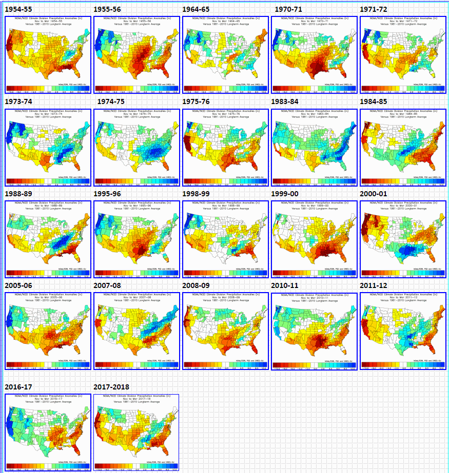
So is this awful pattern the result of La Nina that I'm sure everyone has heard about? I've said it before. La Nina or El Nino only "contributes" to the pattern. We are in a pretty good La Nina at the current time. But to make a forecast based on that? Look at what has happened during past La Nina events. No two are alike and we often see a wide range of weather across the high plains during each one.
Here is the anomaly of precipitation during La Nina events (November through March)...
Here is the anomaly of temperatures during La Nina events (November through March)...
So with the vast differences from one to another, how can one make an accurate predication of what is to be expected based on La Nina (or El Nino)?
The current sea surface anomaly has this....
The cooler than average (La Nina event) definitely is notable from south America west along the equator. But what about that warm blob across the north Pacific? What about that cool area in the gulf of Alaska? That may or may not have an impact. Believe it or not, the northwest Atlantic warmer than normal waters may also be having an affect.
One huge concern I have is the above normal waters in Gulf of Mexico. There will likely NOT be major intrusions of Arctic air into the gulf this winter (maybe very briefly). Thus, I suspect that waters there will be very warm as spring approaches. I already mentioned in posts this past fall that the pattern was set up for above normal tornadoes for Kansas for 2022. I'm not completely sold on western Kansas but eastern Kansas (and points north and south) will likely be under the gun several times. This warm gulf will be the source for the rich moisture needed. Hopefully though, this would also equate to a potential source for moisture for some of the high plains if a weather system can get going west of us. More on that later....
So, going forward. Other than a few days of possible precipitation with the cold air later this month, I'm afraid that February may follow January with several outbreaks of cold but with not many chances for precipitation = maybe just a couple. Fingers crossed. As March arrives, perhaps there will be an improved chance for beneficial precipitation, but I'm not getting my hopes up for now.
Next week (Tuesday and Wednesday, 18th-19th) I'll be presenting at the Cover Your Acres Winter Conference in Oberlin. Perhaps I'll see a few of you there.


No comments:
Post a Comment