For the past few months I've been seeing some similarities to the awful year of 2011 across much of the high plains and briefly mentioned that in several posts. If you look at the precipitation pattern for January through March of this year and compare it to May 1 through July 31, 2011 I think you can see that there is some similarity, especially for southwest Kansas into southeast Colorado and into west Texas.
Here is the current percent of normal precipitation map for January 1 through March 31 of this year...
Here is the period of May 1 through July 31 of 2011...
It was amazing that in 2011 the very extreme dryness ended abruptly going north into northwest Kansas and western Nebraska.
And here is the precipitation for the first 29 days of April...
That is not a good trend for SW Kansas, SE Colorado and into west Texas.
Am I still concerned? Yes, but actually just barely. There have been systems and the threat that they stay north and east of much of the plains is still there. However, now I'm seeing some better signs for at least May. If May can end with decent moisture then that would help mitigate anything very serious in July and August.
In the previous post I did a couple of weeks ago (you can read that here), I ended with this....
"For this past few months I discussed the period of April 25th through May 2. The most likely impact would be colder weather (again). There continues to be a hint of that happening. I think once we get past the 2nd, there should be a dramatic and pro-longed warmup."
Well that's not working out quite as planned. Yes the 28th, 29th and today (30th) have been at or slightly cooler than normal, but this weekend should be pretty warm. A cool down starts Monday the 3rd. But after looking at the pattern again, I now see the trend to a not so dramatic and pro-longed warmup. If fact, I'm now leaning in the opposite direction! Why the change? I feel confident it can be directly tied to a robust Madden Julian Oscillation (MJO). Look at the schematic of the MJO back in February when we had that brutal cold weather and what has started earlier in April...
The current MJO is quite strong and is entering a phase space (specific area of the Pacific)
that in itself can promote a cooler pattern across the high plains. Based on other MJO's in recorded history and located in a similar area, this is what "could" be expected...
Temperature anomaly
And perhaps better news, look at what is possible with the same strength and phase space regarding precipitation!
Precipitation anomaly
If anything, this boosts my confidence for much of May.
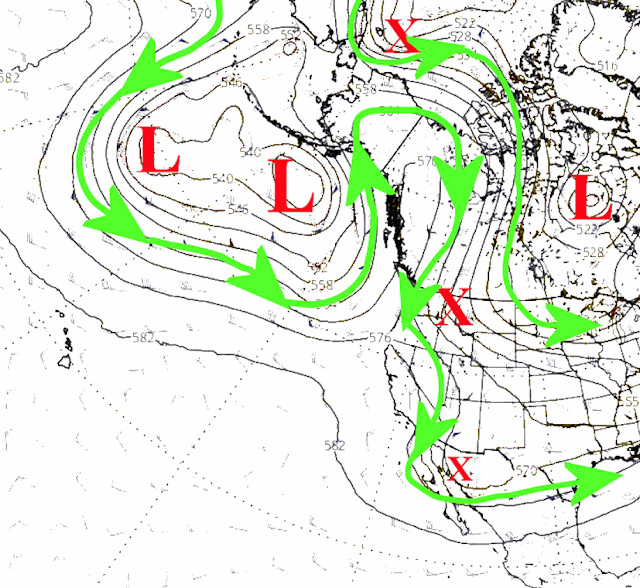
In the nearer term, there should be a complex of thunderstorms late this weekend or Monday. The responsible system is the red X on the following jestream map...
The main question is how far south the complex will be.
One or two more chances will be possible, especially between May 6th and May 13th. Here is the outlook from the Weather Predication Center through next Friday...Thank you again to those that filled out the quick survey (that link is https://www.surveymonkey.com/r/7ZSGTTG) as that will help me decide what I do with these outlook posts. If I retire from the agency I work for, I would be able to do these posts more frequently.


