The excitement during the past week or so was the remnants of a tropical system that moved up into the states from Baja California. It brought copious amounts of rain to eastern Arizona and parts of New Mexico and then eventually excessive rainfall to much of Nebraska as the system moved northeast and stalled over that state. The dying remnants eventually turned south and west and merged into a developing low pressure system over Texas. There was scattered heavy rain across parts of the high plains and also other parts of Kansas. Some locations got a lot of rain and some got very little to nothing at all!
This is the "catch 22" time of year when some need rain for the winter wheat planting and emergence while others may be needing dry weather for harvest and perhaps the last cutting of hay or alfalfa.
The following is a coarse-resolution rainfall map for the period September 20 through September 26. You can even see the banding of precipitation that occurred with the remnants of the tropical system that had been over Nebraska.
Click for a larger map....
The upper low over Texas (mentioned above) was easily detected on the Sunday evening satellite image (but it will be moving east and will not impact the high plains weather)...
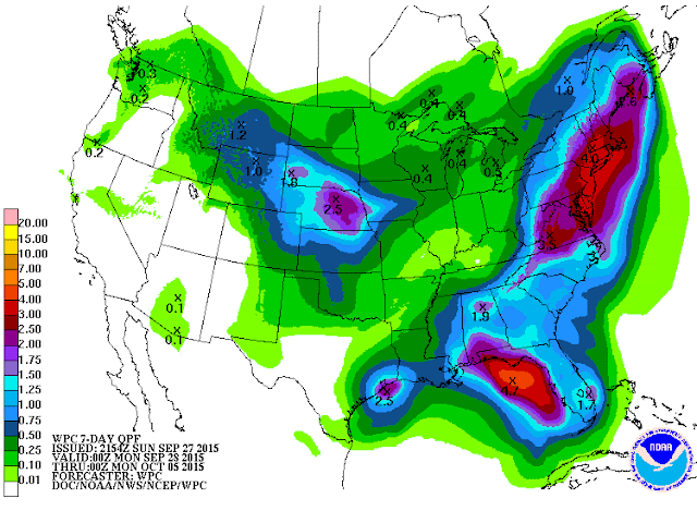
Also on the map was an upper low over central Canada. This cold system brought the first significant snow to Fairbanks, Alaska and adjacent areas. The high country of Alaska and western Canada received very heavy snow. It does appear that part of the energy from this Canada system and another coming out of the Pacific will amplify enough to bring a cold front down into the central U.S. sometime during the middle of the week. Although there won't be "significant" cooling, the front and digging system will bring a chance for scattered precipitation to the central plains. In addition, it appears that downstream energy propagation from a western Pacific Ocean typhoon will bring a stronger front and colder airmass to the central U.S. toward the end of the week. There is a lot of uncertainty in the details this far out, but I suspect that it will get chilly by Friday or Saturday, with an increased chance for precipitation. Here is the outlook from the Weather Prediction Center.
If this verifies, the 2 to 3 inches that could fall on eastern Nebraska could cause some problems as this was the same area hit hard last week.
I will try and post on Wednesday to refine the late week outlook and look ahead to the remainder of October. Could there be a western corn-belt freeze by the 5th of October?


No comments:
Post a Comment