Weather forecasting can be a real challenge some times. In the post I did yesterday I briefly discussed what the computer model was forecasting as far as snow is concerned. That post is here. The potential snowfall map generated by one of the computer models had a stripe of snow from Elkhart to near Dodge City. That map can be found here. The Meteorologist at the Dodge City office where I work was forecasting a swath of 3 to 5 inches based on sound meteorological reasoning and backed up by what forecast models were generating.
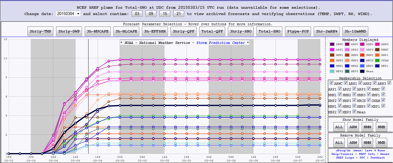
BUT, look at the choices! The following is a plume of possibilities produced by a bunch of different computer forecasting models, each with slightly different initial conditions. The possibilities were all over the place! (click for a full size version)
The possibilities for Dodge City generated by the computer at 9 AM Tuesday morning ranged from around an inch to as much as 10 inches! The median for all of the models was a little over 5 inches.
But, look what happened!
The axis of snow ended up shifting east by about 30-40 miles. Such is forecasting when there are 100 quintillion molecules in the atmosphere that make up our weather. In addition, the storm was still off the coast yesterday morning and was not being sampled by weather balloons.
This also brings me to a point about getting forecast information. Yesterday all of the TV stations, The Weather Channel, Accuweather, Intellicast, etc. were all over the place with a forecast snow amount. Why? Because each probably bases their forecast on just one forecast model and as you can see from the plume above, the possibilities were (and usually are) all over the place.
Our forecasters at the local office got it wrong this time (placement), but it certainly is not always the case (based on pure verification, not just some notion that people have).
There will be just a bit more snow today but then the warmup begins (especially during the weekend). See the previous post from yesterday for that discussion.


No comments:
Post a Comment